


Reducing Cognitive Load: How Decision Support Systems Generate Tempo and Gain the Advantage
by Captain Ryan Helm


There is a largely unspoken flaw in our community—we often don’t plan as rigorously in real-world conditions as we do at live-fire ranges and formal learning centers. In these controlled environments, deliberate planning is often unrealistically slow and supported by ample information, allowing for both comprehensiveness and precision. Think for example, how we walk Range 400 prior to executing company-supported attacks. I recall walking with my lead element to identify the blue spray-painted rock that conveniently marked the minimum-safe distance from 81mm mortars’ linear sheaf across the western objective.
This might surprise some, but that level of fidelity is rarely available when planning from ship, while decentralized, with degraded communications, or during an evolving force-on-force exercise—situations where planning depth and accuracy inevitably suffer.
So, with limited time or information, how do we maintain depth in tactical planning to maximize our unit’s lethality and survivability? This tension shaped my perspective as a junior officer. I often felt under-equipped to maintain high standards of comprehensiveness or precision in planning with the resources available to me.
My solution as a platoon commander: plan as thoroughly as possible, but recognize that some decisions must be made at the point of information, from the point of influence.
Ultimately, for all of us, gaining experience navigating low-information environments builds sharper decision-makers—comfortable briefing simple, redundant, and flexible plans resilient to dynamic environments and the fog of war. The ability to operate gracefully and effectively despite uncertainty is what defines varsity leaders and units. Through familiarity, standard operating procedures, and necessity, a unit builds tempo—executing audibles in a no-huddle offense at the speed of combat orders: “three sentences in thirty seconds or less, under fire.”
Yet, just because we must be capable of thriving in low-information environments doesn’t mean we should accept them as risk when avoidable.
What if we could harness geospatial data and automation to generate the point of information sooner—before a leader’s recon or first contact with the enemy? Loading the assault position is not the time to discover that terrain and geometry-of-fire limitations will get Marines killed. Recognizing this capability gap, I developed the tactical-decision support system that I wished I’d had as a junior officer—one that digitally translates the “science” of ground combat maneuver planning into rapid, actionable insight.
The outcome of this effort is called ARES—Augmented Reconnaissance and Estimate of the Situation—named for the Troop Leading Steps it enhances. For tactical planning, ARES:
Decentralizes geospatial intelligence (GEOINT)—putting HLZ prediction, route planning, and direct-fire geometry analysis in the hands of maneuver leaders
Expands decision space by saving time—accelerating planning without sacrificing depth or accuracy
Integrates with TAK-based tools on Android and desktop—ready today for immediate use
This article introduces you to that decision support system—how to download it, employ it, and leverage its capabilities to support you and your Marines.
A Journey to Improve Tactical Planning
Shortly after arriving at Naval Postgraduate School for my second tour, I realized that I could leverage my education to improve decision-making tools for our community. Certain components of the tactical thought process could be automated. Tools like HLZ prediction, route planning, and line-of-sight analyses were not new—Geospatial Intelligence (GEOINT) Specialists could already perform them. However, I wanted to package them into an infantry-centric toolset and decentralize these capabilities down to maneuver leaders—beyond the battalion operations center.
The novel contribution of my work was integrating these elements to algorithmically generate complete, doctrinal, and executable courses of action (COAs). I built a system capable of considering all combinations of insertion locations, maneuver corridors, enemy visibility, and geometries-of-fire to recommend optimal COAs. That system became an initial proof-of-concept application called Augmented Reconnaissance and Estimate of the Situation (ARES).
ARES achieved my vision for a system capable of producing feasible, optimal COAs within the “science” of doctrinal ground-force maneuver planning—allowing leaders to quickly wargame plans with the time saved. Instead of manually plotting geometries and evaluating lines-of-sight, a commander could focus on contingencies, transitions between subordinate unit actions, and enemy reactions.
To validate ARES, I tested it against named exercises and training events to determine whether it produced COAs comparable to range-walk informed live-fire exercise designs. If the system could generate a COA on par with a pre-planned training exercise, then it could do the same anywhere—without a range walk or leader’s recon.

ARES underwent its first validation testing when Battalion Landing Team (BLT) 1/5 employed the standalone application to support several ship-to-shore maneuvers during their pre-deployment training period (PTP). The after-action review (AAR) identified two key findings:
ARES rapidly provided non-obvious yet optimal COAs that maximized cover, geometries of fire, and economies of force
ARES required a legitimate software development cycle to integrate government data sources and build a robust user interface.
Additionally, the battalion shared these comments:
Overall, ARES provided an expedient, objective-focused analysis of key military aspects of terrain and evaluation of terrain effects on troop movement, allowing raid force planners to quickly compare and exploit the effects of terrain on enemy and friendly forces…
ARES offers tremendous value to infantry battalions, from junior intelligence analysts to company commanders and the operations officer. Its uses are not limited to vertical assault raids; it may assist planning for all offensive operations, as well as defense and security operations by suggesting likely (optimal) enemy courses of action.
—BLT 1/5 WESTPAC 24.1 PTP Lessons Learned (Unclassified), 1 August 20241
ARES Availability
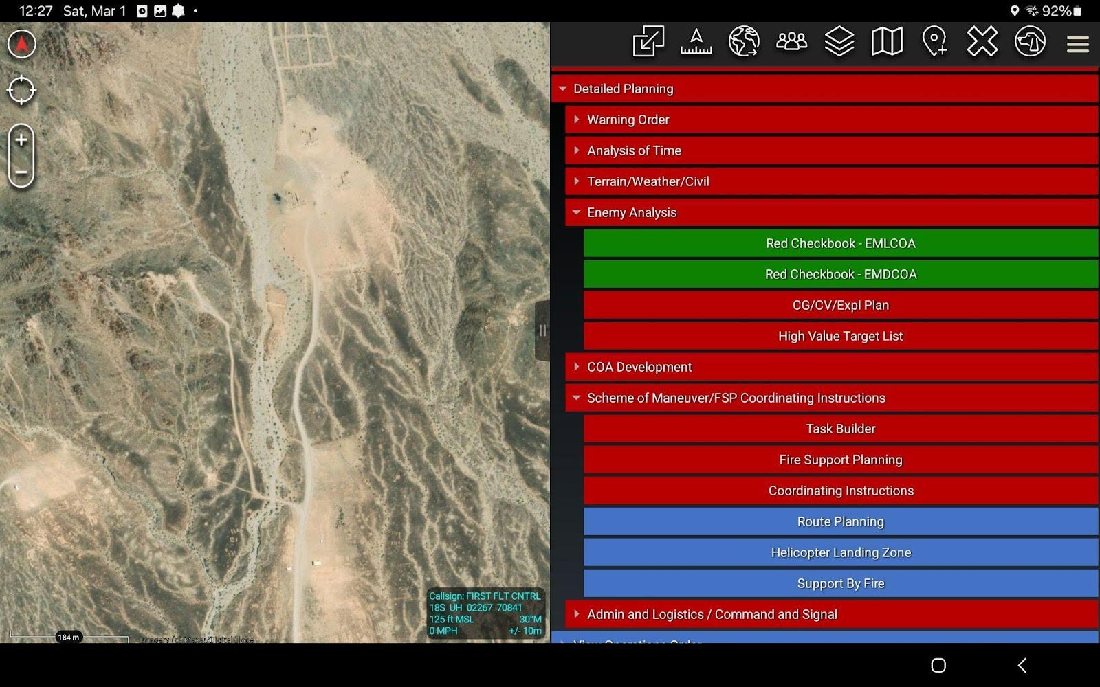
Today, ARES is not a standalone application; rather, it has been integrated to enhance larger-scope planning aids on the Tactical Assault Kit (TAK) platform. The Office of Naval Research (ONR) Warfighter Dominance program (Code 34) is developing two TAK-based tactical planning plug-ins: Small-Unit Mission Planner (SUMP) and Higher-Echelon Mission Planner (HEMP). SUMP is an Android TAK (ATAK)-based application for building Operations Orders on tablets, while HEMP is a webTAK-based browser application to facilitate collaborative execution of the Marine Corps Planning Process (MCPP). Both provide a guided digital workflow for operational planning, accelerating the process and generating transmittable digital artifacts that can be shared and collaborated on by subordinate and higher units.
If you need user training for your unit or would like to provide feedback on SUMP or HEMP, contact sumpteam@us.navy.mil.
Marine Innovation Unit (MIU) Coders have been iterating on a standalone ARES HLZ plug-in with Weapons and Tactics Instructor (WTI) Course. This plug-in, intended for baseline ATAK installation on Marine Air-Ground Tablets (MAGTABs), will become available this summer.
For more information on the MAGTAB ARES HLZ Predictor, contact Maj David McGee, MIU Coders, at david.mcgee@usmc.mil.
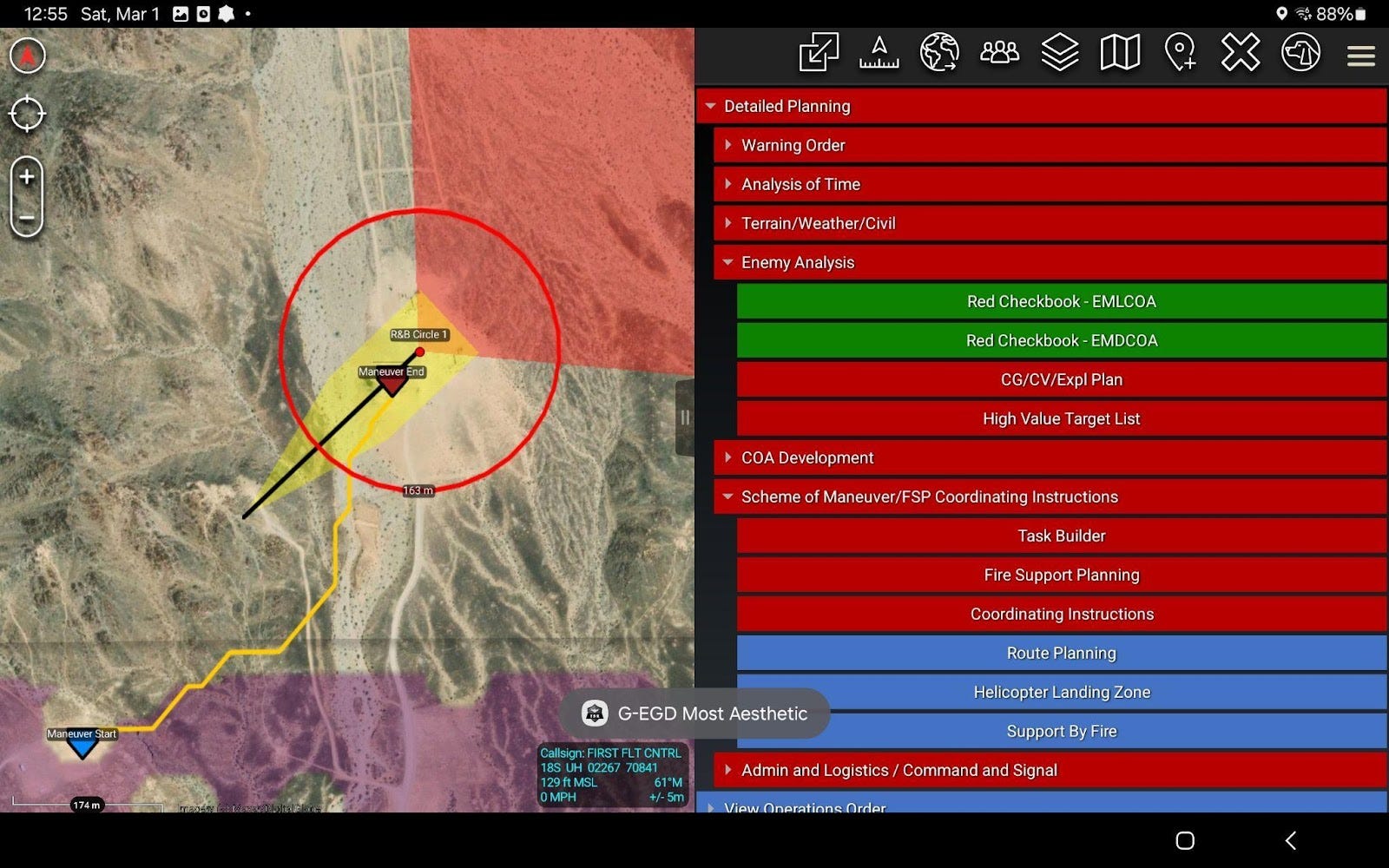
How to Get Started
For now, installing SUMP on a personal Android device is the best way to begin experimenting with tactical decision support systems. (Installation instructions are included at the bottom of this article).
First, I’ll walk through SUMP’s capabilities using a Range 410A air assault as a scenario.
Recall at Range 410A, an enemy squad (reinforced) is defending in sector in order to deny friendly forces access through Cleghorn Pass. Their position consists of three mutually supported trenches with medium machine gun bunkers. We will use four SUMP tools (derived from ARES) to plan our clear of the Cleghorn Strongpoint:
Red Checkbook
HLZ Predictor
Support By Fire (SBF) Planner
Route Planner
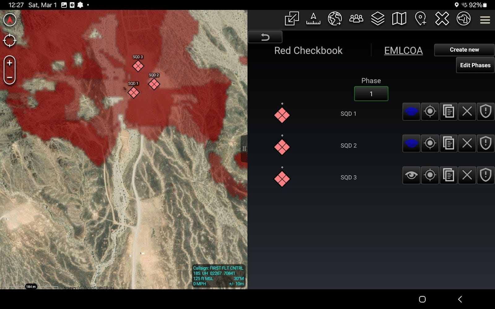
Enemy Analysis
We start with the Red Checkbook - EMLCOA tool, placing three squad battle positions over the trenches. Using the viewshed (line-of-sight) tool, we analyze enemy fields of fire and observation lanes to identify key terrain.
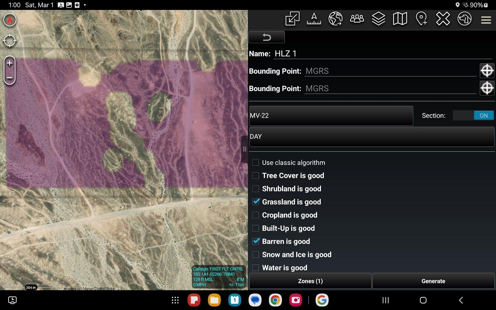
Helicopter Landing Zone Analysis
Next, we determine our insert location. With the HLZ tool, we draw a bounding box around the area of interest and set it to return feasible HLZs for an MV-22 section. The tool generates purple regions, indicating all possible HLZ center points while accounting for vegetation restrictions and slope limitations specific to the airframe.
ARES [HLZ analysis] must be employed by or with GEOINT analysts and compared with other imagery sources to correct for the tool’s current limitations, based on its data sources, with regard to accurate accounting for vegetation, buildings, powerlines, etc…
—BLT 1/5 WESTPAC 24.1 PTP Lessons Learned (Unclassified), 1 August 2024
Support by Fire Analysis
Now, we need to identify support-by-fire (SBF) positions and determine the optimal combination of SBF and maneuver corridor to maximize cover, economy of fires, and concentration of fires at the trench system’s entry point. After selecting a target and defining weapon system parameters and employment methods, the tool overlays all feasible SBF positions in blue. Each circular point in the overlay represents a position that minimizes enemy exposure for the SBF element—all positioned behind terrain relative to the trench system. Selecting a point automatically generates gun-target lines (GTLs), minimum safe lines (MSLs), and surface danger zones (SDZs).

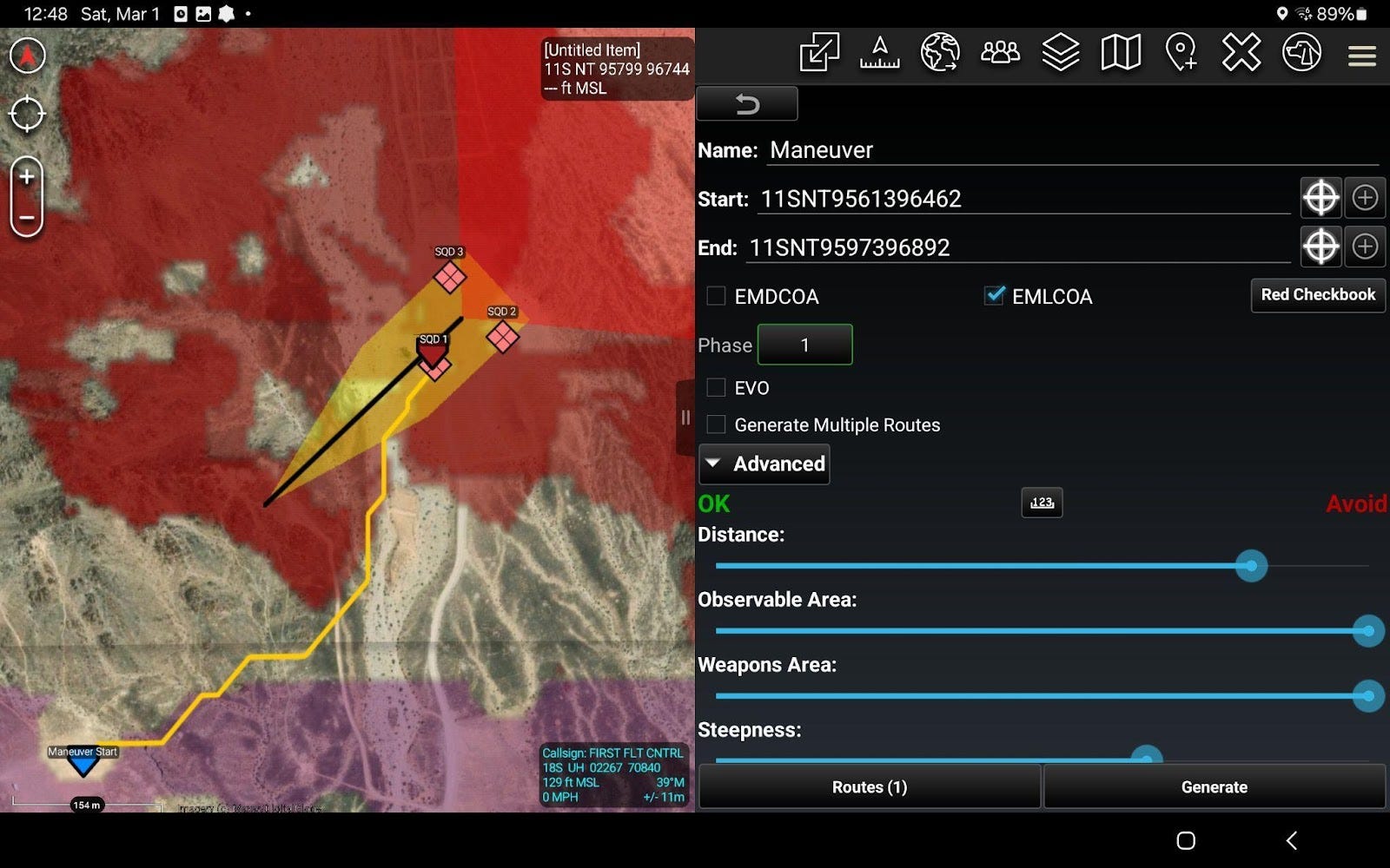
Route Planning
With the SBF positions set, we generate the maneuver corridor. I select a covered HLZ southwest of the Cleghorn Strongpoint, adjust risk-assessment preferences, and the system generates the optimal route in orange. When adjusting risk-assessment preferences, think speed vs. security. Think, in my tactical judgement—what terrain or enemy conditions constitute security for my unit? Am I willing to sacrifice any amount of time to achieve security, or will time get a vote? The tool provides route length in meters, estimated travel time, and a breakdown of exposure—specifically, how many meters are unconcealed, observable, or within enemy fields of fire.
Below, you’ll see that I adjusted risk-assessment preferences with the sliding bars: between “Avoid” and “OK”. In the screenshot, I’ve told the algorithm that areas observable by the enemy or within their fields of fire are the most dangerous to me, and that flat terrain (steepness) and speed (distance) are only of moderate importance to me.
Indirect Fires
Given this scheme of maneuver, we confirm that our SBF element will require indirect fire suppression during occupation—they will be exposed to enemy fires before reaching their positions. Using the native ATAK range-ring tool, we drop the deviated minimum safe distance for 60mm mortars and determine that the mortar firing position must be offset southeast to prevent fires overhead of friendly troops.
Conclusion
…ARES rapidly generated preliminary geospatial analyses that could significantly focus efforts for IPB Step 2 ("Describe the Effects on Operations"). Through the HLZ detection tool, ARES quickly provided feasible HLZs masked from enemy observation and weapons engagement. The program could then provide optimal route selections, complemented with time distance analyses (TDA) from the HLZ to the objective, with considerations for sloping terrain, roads, urban infrastructure, enemy observation, and enemy weapons capabilities. Finally, ARES could recommend optimal engagement positions that maximized the ability of maneuver elements to close on the objective under the coverage of supporting fires. Overall, ARES provided an expedient, objective-focused analysis of key military aspects of terrain and evaluation of terrain effects on troop movement, allowing raid force planners to quickly compare and exploit the effects of terrain on enemy and friendly forces.
—BLT 1/5 WESTPAC 24.1 PTP Lessons Learned (Unclassified), 1 August 2024
Integrating decision support systems like ARES and SUMP into tactical planning enhances speed, precision, and comprehensiveness—mitigating the risks of time or information constraints. These tools do not replace tactical intuition or adaptability; they augment them—reducing the cognitive burden of terrain analysis and COA development, allowing leaders to focus on wargaming, contingencies, and transition.
Ultimately, speed in planning and execution is not just about moving faster—it’s about making better decisions sooner, forcing the enemy into a reactive cycle while maintaining the initiative. By accelerating the planning process without sacrificing depth, these tools enable units to compress decision-making time, maintain tempo, and act inside the enemy’s decision loop.
Capt Ryan Helm is an Infantry Officer and currently serving as an Operations Research Analyst at Manpower & Reserve Affairs. He is a graduate of Naval Postgraduate School where he earned a Master of Science in Operations Research. He can be reached at ryan.helm@usmc.mil.
Have ideas or experiences that could benefit other infantry and reconnaissance leaders? We need to hear your voice! The Connecting File depends on the willingness of readers to share lessons learned. Read more here about how you can contribute to our community.
The opinions expressed above are those of the author and The Connecting File. They do not reflect the views of the Department of Defense, the United States Marine Corps, or any other government entity.
Battalion Landing Team 1/5. (2024, August 1). Western Pacific 24.1 Pre-Deployment Training Period Lessons Learned. Marine Corps Center for Lessons Learned.
SUMP/ARES Download & Installation Steps (personal devices only)
Disclaimer: All geospatial data and imagery used in this article are open-source. When you install TAK-TICS, some imagery may not be unclassified. Read the TAK-TICS Terms of Agreement and beware of derivatively classifying any planning products you create.
From your computer:
Create an account on TAK.gov. This requires a Common Access Card (CAC), CAC reader, and authenticator application.
Download the SUMP APK from the plugin page by clicking the blue download box. Note what version of ATAK you need, which is ATAK version 5.3.0 at the release of this article.
Download the ATAK APK from the ATAK-MIL page. Change to ATAK version 5.3.0 (or whatever version SUMP is currently on). Click the blue download buttons for:
ATAK-...-CIV-RELEASE.APK
ATAK-SYSTEMPLUGIN-FLAVORPLUGIN-...-MIL-RELEASE.APK
For imagery streaming, download the TAK-TICS APK from the plugin page. Ensure you choose the same version of ATAK.
Transfer the four APK files from your computer to your tablet.
From your tablet:
Install the APKs (by opening them):
ATAK CIV RELEASE then ATAK MIL RELEASE
SUMP
TAK-TICS
From within ATAK, open the TAK-TICS plug-in to accept the National Geospatial Intelligence Agency (NGA) disclosure agreements and link your TAK account credentials.
Glad to see this article! Ryan, THANK YOU for all the work you've put into ARES (and its successors) long after leaving NPS. We tested a lot of interesting tech on the 15th MEU; I think ARES was the best. Thrilled to see it available to all Marines on TAK.
This month's ACE-focused Gazette included an article calling for an optimization / math-programming approach to exploring and advancing strike/fighter tactics ... glad that we in the infantry (thanks to you) got there first!
Love the work. Love this: "These tools do not replace tactical intuition or adaptability; they augment them—reducing the cognitive burden of terrain analysis and COA development, allowing leaders to focus on wargaming, contingencies, and transition."