


Grounding Reconnaissance: Can Our GCE Get Where It’s Going?
by Jesse Perkins, Mary Hawes, Justin Shin, James Myles, and Nick Freeman


This article is about a critical vulnerability in our ground combat element: inadequate capacity to assess terrain and routes in support of maneuver. At the very moment the Marine Corps is most intently focused on operating across maritime East Asia—a vast area characterized in many places by limited natural mobility and less-developed infrastructure—its vehicles have grown larger, heavier, and more road-bound than ever. Commanders’ margins for error have shrunk accordingly. Can that bridge support my ACVs? Will my NMESIS launchers make it around those switchbacks? How many JLTVs can go down that path before it turns to slop? If we are to operate across the First Island Chain, these are questions that commanders will ask every day. Yet our ability to answer them remains underappreciated, underdeveloped, and insufficiently practiced.
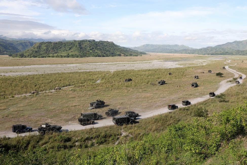
Our assessment comes from recent, on-the-ground experience. We were members of a battalion landing team that operated throughout East Asia’s periphery across a ten-month, staggered MEU deployment. We brought ACVs, for the first time, to the Philippines, Okinawa, and South Korea. Our Marines drove, for the first time, JLTVs, MTVRs, and M777s across the island of Palawan. They operated heavy tactical vehicles in Indonesia, Malaysia, and Thailand. And everywhere we tried to go, we struggled to determine, quickly and accurately, whether shallow nearshore approaches, mucky beach exit points, tight switchbacks, narrow roads with low-hanging tree limbs and power lines, and countless small bridges would support their mobility. In conflict, this lack of sufficient reconnaissance capacity and so many resulting delays could have been disastrous.
How do we fix this vulnerability? This article is meant to give GCE leaders a better sense of what is currently possible with well-established techniques and practices, most of which see too little use outside our combat engineer battalions (CEBs). We believe these capabilities can and must be expanded throughout our broader reconnaissance enterprise, placing them forward into our security areas to answer the kinds of questions posed above. We also highlight several ready technologies that could make expanding these capabilities relatively easy while greatly improving their speed and accuracy. Our current situation is serious, but we’re confident it can be improved.
Note: The term “reconnaissance teams” in this article refers to all GCE elements with reconnaissance missions, including the reconnaissance battalions, light armored reconnaissance (LAR) units, and infantry battalion scouts.
Terrain Like You Fight
You can’t focus on the enemy if you’re stuck. Exposed and immobile, you’re an easy target, while also blind to what your adversary is doing. Yet across our GCE, too few Marines possess the formal learning and sustained training necessary to determine what routes and terrain will keep us moving. This might have been less of a problem when our vehicles were smaller and lighter (HMMWVs, AAVs), when we operated in places with more-open terrain and decent road infrastructure (Iraq), or remained primarily dismounted in smaller areas of operation (Afghanistan). But none of these factors will be in play across the dense jungle, extensive mountains, and limited road networks of the First Island Chain, particularly in its southern reaches. If deployed to fight there today, it is almost certain that we’d be challenged to execute rapid maneuver due to our inability to complete necessary ground reconnaissance.
Why are we this way? One clear reason is that our reconnaissance enterprise simply has too many other training priorities: among them, specialized insert methods (recon battalions), specialized limited-scale raids (ditto), support to maritime interdiction operations (ditto, again), security tasks (LAR), and surveillance and target acquisition (infantry battalion scouts). There are, of course, our engineers. Yet despite the years they’ve spent trying to educate other GCE leaders on the importance of “engineer reconnaissance”—a doctrinal term we think is actually a misnomer for techniques inherent to almost any route reconnaissance mission—we continue to lack well-practiced concepts for employing these capabilities forward, in the security area, and not simply as part of civil affairs-led infrastructure assessments.1 Thus, we have inadequate capacity for route, bridge, and terrain-trafficability assessments both because we don’t consider these to be important skills for “real” reconnaissance units, and because those same “real” reconnaissance units are too busy training for so many non-reconnaissance missions.2
But if the GCE currently suffers a major supply problem in terms of terrain- and route-oriented reconnaissance capacity, it’s partly because we’ve also established a long running false negative in terms of our likely true demand. We believe there is a clear mismatch between what GCE leaders ask for during peacetime training at home station and what they’ll actually need when operating on unfamiliar terrain. Unfortunately, our major training exercises all take place in the same locations. Leaders fighting “in scenario” already know Camp Lejeune (MCCREs), Camp Pendleton (MCCREs, STEEL KNIGHT), and MCAGCC (SLTEs) like the backs of their hands. Their collections tasks therefore tend to be exclusively focused on the enemy, not the terrain and the routes across it. Why shouldn’t they be? They’ve been training in those haunts since they were lieutenants, and maybe they even passed by that same objective last week. But by not asking for terrain-oriented collections actions in training, we have allowed these capabilities to remain underdeveloped and under-practiced. We need more than just a few engineers who can answer what may be some of our most pressing and widespread questions at the outset of our next fight.3
Our alarm is not hypothetical. Lack of basic technical survey capabilities throughout our reconnaissance enterprise is already hurting us now, in competition. On our recent deployment, we had to delay, modify, or even cancel planned operations in both the Philippines and South Korea4 as a result of insufficient or incomplete route assessments. Everywhere we went, fewer than perhaps ten qualified Marines out of 2,500 attempted to survey countless winding roads and thinly built spans in time for our lumbering ACVs, JLTVs, and other vehicles to transit them (or not).5 Such limited capacity may not only make dynamic, extended, widely distributed operations by a future stand-in force unsustainable—it also hampers our ability to conduct effective exercises, rehearsals, and preparations today.
To better educate GCE leaders, the following provides more details on the reconnaissance capabilities we must expand and push forward.
What’s the Grade, Curve
Every route that you travel has several defining characteristics: a tightest curve, a steepest grade, a narrowest width, and surface and/or subgrade characteristics that may be affected in different ways by the weather. Some also have overhead obstructions like overpasses, tunnel ceilings, dense foliage, or power lines—and among these obstructions, one of them will be the lowest (most limiting). The measurements for these defining features, and those features’ locations, enable a comprehensive understanding of what vehicles may travel that route, and how.
There is also a doctrinal method for presenting all this information—one that too few of us in the GCE are familiar with. Called a “route classification overlay,” it presents the above information about as cleanly and succinctly as possible. Figure 1 provides an example from the applicable reference. Don’t despair over how complex it first appears—this example is deliberately chock-full of features that not all routes will have, and corresponding measures that not all reconnaissance teams must be able to complete. The simple take-away is that with the information gathered, we have a straightforward template for how to present it in support of commanders’ decision-making.

Although we have a standardized list of route features to measure, standardized methods of making those measurements, and a standardized way to present them, GCE elements tasked to perform route reconnaissance seldom follow these standards. More often, we receive imprecise reports of a “tight curve” some X meters beyond a “steep climb.” Even a recent cross-functional effort to classify Camp Pendleton’s roads for tactical vehicle traffic produced only a non-standard, stoplight-style, occasionally confusing green/yellow/red set of overlays with actual information limited to road widths and grades.
There are clear, doctrinal methods for route information collection and presentation. We in the GCE need to train our reconnaissance teams—but most importantly ourselves—to follow them.
How Load Can You Go
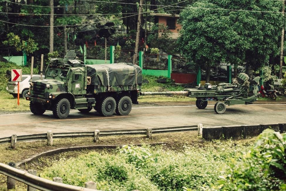
In order to answer the question, “How can the artillery battery best reach its planned firing position on the other side of Palawan?,” a team of four engineers needed two weeks to survey hundreds of miles of road and—no exaggeration—341 bridges. Our fires assets are large and heavy—and, as we once forgot to consider, even heavier when being towed. Many small bridges across the First Island Chain are not built with those kinds of weights in mind. They also tend not to come with posted limits—meaning It's enough to make a grunt’s eyes glaze over: determining what amount of weight a bridge can support requires classifying its load-bearing design, assessing its material composition, taking several measurements for thickness and length—and then combining all that information through various formulas to produce an estimated “military load capacity” (MLC) rating, which may be compared against minimum one-way MLCs for various vehicles. The reference for these procedures tops 500 pages and includes over 350 formulas.
If you think that sounds like a bit much for your average GCE Marine, you might be right—but there’s a reason we’ve always held the members of our reconnaissance teams to higher standards. In any case, the impetus is clear: we must figure out how to expand our capacity for these technical assessments, and employ such capability forward as part of fast, hard-to-detect collections efforts. If we can’t train current reconnaissance team members to do this, then we need to train engineers to be members of reconnaissance teams. Otherwise, you, too, might be waiting two weeks—or indefinitely—to figure out whether your stand-in forces can move somewhere in your AO. We won’t have that kind of time.
Better Eyesight with Rods and Cones
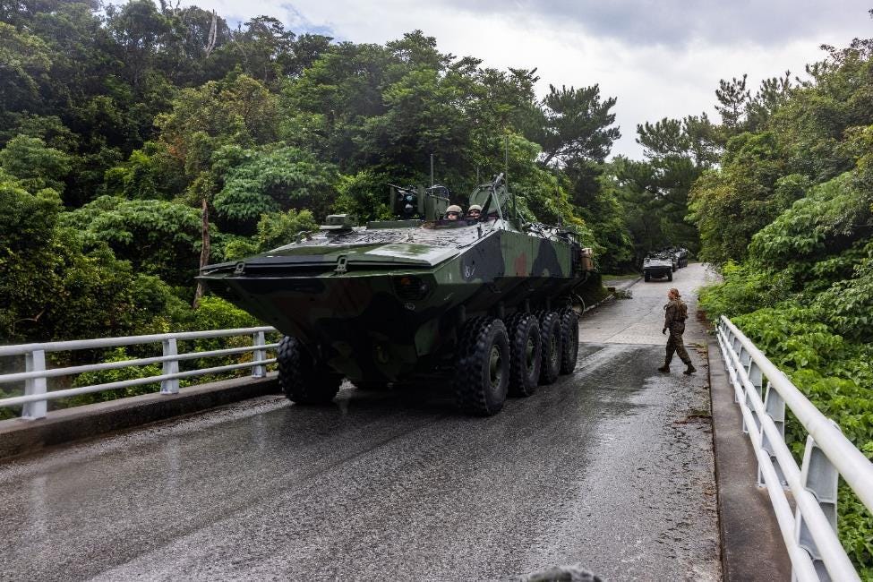
Our new assault amphibian vehicle has wheels, allowing it to go far, and fast, on roads. The tradeoff? Soft sand and wet soil can pose some challenges. While the tracked AAV offered a ground pressure of just 9.7 psi (among the lowest of all military vehicles in the world), the 70,000lb, eight-wheeled ACV’s may top 50 psi in many conditions. This means significantly more force exerted on ground beneath it, with associated effects—over one, a few, or multiple passes—like turning soft soil into mud, mud into muck, and muck into deeply mired vehicles.
Our engineers have long-established practices for quickly sampling and assessing soil trafficability. Using two simple, hand-carried instruments called the cone penetrometer and remolding cylinder, Marines with some additional training are able to obtain an average rating cone index (RCI) for a given area of ground. This measure, which provides an indication of soil strength (and thus trafficability), can then be compared to a vehicle’s vehicle cone index (VCI) for 1, 9, or 50 passes (VCI1, VCI9, VCI50). A VCIX less than or equal to an RCI means that X of those vehicles likely may pass over the same ground before miring occurs.
We don’t need to know the RCI measures for everywhere—nor would we want to spend all our collections efforts measuring every patch of ground. But when choosing, say, a future firing position or determining mobility corridors for a mobile counter-landing defense, estimates of soil trafficability in one or a few locations may be critical to our planning. Any CAAT platoon commander knows how important it might be to choose one route over another in order to keep his vehicles from getting stuck.
Yet the GCE’s entire reconnaissance enterprise has almost no ability to take these measurements. Even 1st CEB currently possesses no penetrometers or remolding cylinders. A Marine Division simply cannot answer, with any measurable confidence, questions about its own ability to maneuver across tidal flats, river beds, agricultural fields, or rain-soaked dirt roads—all common features in the First Island Chain. As long we lack such a capability forward with our reconnaissance teams, we will be driving blind in an unforgiving AO. When we are distributed across a vast region and seeking to remain untargeted, an ounce of soil-measuring may be worth many pounds of additional wrecker support.
No Reach Beyond Beach
As part of an overall amphibious force (AF), the GCE needs to help improve reconnaissance practices for getting to, and beyond, the beach. Shortfalls in both doctrinal prescriptions and current practices pose significant risks to our operations along the First Island Chain. There, the shores and approaches are often characterized by numerous shoals, shallow depths, significant coral, extensive commercial activity (from massive container ships to thousands of crab traps), narrow beaches, scarce exit points, and underdeveloped road infrastructure leading inland. Few parts of the world place such a premium on thorough amphibious reconnaissance.

Thorough, however, does not describe our current practices. To begin with, the AF has no standardized requirements or procedures—let alone organizational constructs or equipment—for confirming suitable bathymetric conditions beyond the nearshore, where the landing craft and assault vehicles carrying us ashore will transit.6 In a part of the world where many charts are old, incomplete, or nonexistent, such lack of standard practice is a serious liability.7 It doesn’t get much better for us at the beach. Despite this being a perennial point of contention, the US Navy still does not accept (peacetime) beach surveys completed by US Marines.8 Meanwhile, we have yet to fully standardized required beach characteristics for our own ACVs.9 Beyond the backshore, the GCE’s lack of technical survey expertise means reconnaissance teams are rarely tasked, let alone able, to assess whether exit points, routes, and bridges will support necessary mobility inland. When you put all this together, it almost sounds absurd: reconnaissance Marines practice beach surveys that the Navy will not accept, assessing criteria for every landing craft/vehicle but our own, while not practicing to determine whether any of our vehicles, once landed, can move past the beach to where they need to go.
Across the First Island Chain, the need for bridge assessments as part of standard amphibious reconnaissance is not a matter of “if.” The best beaches for landings—wider, flatter, absent of significant coral—are often that way because a river mouth has deposited plenty of sand there. Where a river has deposited lots of sand, there are usually one or more meanders closely paralleling the shore. And where those meanders exist near the shore, the only routes inland from the beach are likely to cross one or more bridges. So, where there’s a beach, there’s (likely) a bridge. We’ll want to know if it can support our vehicles.
A Ground Reconnaissance Renaissance?
Up to this point, we have focused on GCE ground reconnaissance shortfalls. Now for the good news: we currently have better opportunities than ever before to address them. Technological advancements and Force Design-driven changes have set the necessary conditions. Tools exist today to make and synthesize necessary measurements faster, more accurately, with fewer people and with less technical training. And ongoing organizational changes have opened the way to new skillsets: our LAR battalions are examining how to provide reconnaissance across the littorals, our infantry battalion scouts are poised to add more depth to their reconnaissance skills, and our engineers are refocusing on technical survey capabilities. The time is ripe for a reconnaissance renaissance.10
So what might it take to put the “ground” back in ground reconnaissance? We suggest the following.
Expanded fielding of automated route survey tools
Since 2009, the Army and Marine Corps have fielded versions of the Instrument Set, Reconnaissance and Surveying, also known as the ENFIRE. This is a suite of government and commercial off-the-shelf (GOTS/COTS) hardware and software tools that generate and synthesize geospatial information. Simply put, the ENFIRE makes survey work fast, accurate, and (almost) as easy as driving down a road. It was practically meant to be put in the hands of non-specialists. Yet they are only fielded to our CEBs, and in limited numbers. Our Divisions should ask for, and our Service should consider, fielding more tools like the ENFIRE—along with necessary new equipment training—across our GCE reconnaissance enterprise.
Automated bridge survey tools
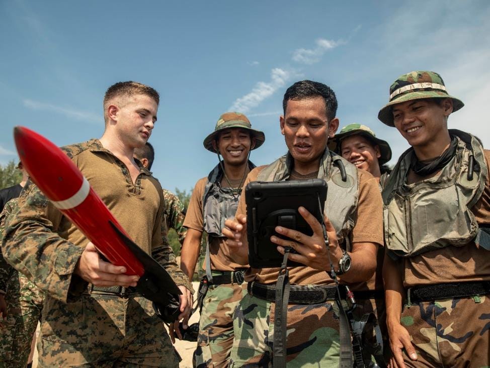
As mentioned earlier, bridge assessments are complicated by the need to perform a lengthy sequence of calculations according to dozens of “if X, then Y” criteria. A tablet-based software application could simplify these steps while reducing the chances for human error—thereby opening the door for more Marines to perform this necessary reconnaissance work. Such a software tool could also make each assessment more traceable and verifiable, by allowing users to take and store pictures of each bridge with embedded scale (width/length/height) information. An application like this really shouldn’t be hard to develop—in fact, BLT 1/5’s S-2 built one using Microsoft Excel during our deployment.11 Marine software developers might be able to produce something much better in a matter of weeks.
Expanded soil sampling capabilities
Cone penetrometers and remolding cylinders are currently fielded only to the LCE’s engineer support battalions (ESBs) and the ACE’s Marine wing support squadrons (MWSSs). We believe the GCE’s CEBs—at a minimum—need these, too. With these tools, the GCE must also advance TTPs to take these measurements in a unit’s security area while minimizing chances for detection by the enemy.
Aerial drones
For several years, the Marine Corps has equipped select units with drone-based software for creating 3D models of terrain and infrastructure. Earlier this year, the California Department of Transportation (CALTRANS) reportedly used autonomous drones to model and monitor progress on a mile-long bridge construction site. Clearly, the technology exists for drones to do almost everything that the ENFIRE and a human bridge surveyor can do. Limited soil sampling is likely possible as well. If the Service isn’t doing this already, we should seriously explore drone-based tools for automated technical surveys. In the meantime, GCE units should seek allocations of their Divisions’ Reveal FarSight software so that their intelligence and reconnaissance teams can practice collecting 3D-modeling data in support of commanders’ information requirements.12
Aquatic drones
On the 15th MEU, we benefited from a low-cost, easily employed aquatic drone for taking simple bathymetry and hydrography measurements. Systems like this can support selections of beaches, boat lanes, and river crossing and fording points. For our reconnaissance battalions’ amphibious reconnaissance and our LAR battalions’ littoral reconnaissance missions, unmanned and autonomous underwater measurement devices present tremendous opportunities to expand reach and accuracy while minimizing signature.
Putting engineers forward
Given current technical-survey capacity limitations, we believe the GCE needs to regularly practice integrating engineers with forward reconnaissance elements. This must be done frequently, not just within major exercises, with deliberate intent to advance integrated TTPs for technical survey work without enemy detection. The FMF currently lacks well-developed SOPs for this, a sign of how infrequently this kind of integrated training occurs.13
Expanded technical survey training
As the Basic and Advanced Scout Courses continue to receive refinement, our Schools of Infantry should consider not whether, but how much instruction in route reconnaissance they must include. Ultimately, the requirement is clear: our scouts must be able to reliably inform critical decisions about where and how an infantry battalion can maneuver its heavy vehicles across uncertain road networks. Formal training within the LAR community could be expanded as well. Currently, students at the LAR Leaders Course (for officers and unit leaders) and Vehicle Commanders Course receive assessment of their abilities to perform basic route measurements. However, LAR scouts, the Marines who actually perform the measurements on the ground, do not receive formal instruction.14 Ultimately, expanding technical survey training for the GCE may require expanding some course seats at the Marine Corps Engineer School, whether for scouts themselves or for those who will train those scouts. The Service could also consider the NATO Military Engineering Center of Excellence’s (MILENG COE) four-day Bridge Assessment and Reconnaissance Team Course as a possible model for training necessary skills in a short amount of time.
Exercise employment
As discussed earlier, our training exercises need to force route, bridge, and terrain-trafficability assessments as part of intelligence preparations of the operational environment, even if commanders already intimately know the ground they’re training on. When we don’t do this, we not only fail to ensure that conditions match our expectations and risk controls; we also effectively “cheat” within the scenario by unrealistically reserving all our collections bandwidth for other information requirements. This might gain us a slight advantage over an exercise adversary force or simply the exercise timeline. But in the long run, we hurt ourselves by failing to register a consistent demand for much-needed reconnaissance capabilities, thereby causing their continued de-prioritization across units, schoolhouses, and combat systems programs.
MCCREs
When an engineer platoon joins an infantry battalion MCCRE, assessments tend to narrowly focus on simple platoon- or squad-level obstacle breaching and, perhaps, obstacle emplacement. We recommend that critical reconnaissance skillsets also receive attention. For a platoon of engineers, that could mean operating as a battalion-level asset, performing route surveys forward of the main body and just behind an LAR screen line; or it could mean providing detachments to LAR and infantry scouts to perform that work as part of those reconnaissance elements. Either way, evaluating engineers for their reconnaissance support not only reinforces their skills, it also trains the supported unit in developing necessary terrain-oriented information requirements and employing collections assets accordingly.
Route classification overlays for every base
We suggest that every Marine Corps training installation should maintain doctrinal route classification overlays for all roads and trails. We recommend the resident Division supports this effort with regular reconnaissance updates, with obvious benefits for our own Marines’ training, our collective TTP advancements, and all tenant units’ education, planning, and risk management.
Conclusion
The above recommendations mostly apply at the Division, MEF, and Service levels. But many of us can also start addressing reconnaissance shortfalls in other ways, right now. We can ensure our own unit’s reconnaissance teams possess the knowledge and tools to conduct at least basic assessments of routes and terrain, and deliberately task them to do so in tactical scenarios. We can place more importance on producing modified combined obstacle overlays, and better use them to drive our collections plans and schemes of maneuver. And we can seek more opportunities for cross-MOS learning and teamwork between our reconnaissance teams, engineers, and ACV and long-range fires units.15 Initial steps like these may be small, but they’ll be significant nonetheless for the direction they take. They will also undoubtedly lead to more ground-level collaboration and learning across different units. From those lessons will undoubtedly follow better recommendations for our GCE and the Service than those we submit here.
There’s also no time to waste. If we are to operate throughout the First Island Chain—and we already are—we can expect to contend every day with rough terrain and questionable roads. Learning from our engineers and leveraging current technology, we can and must quickly improve and expand our capabilities to match the associated demand for route, bridge, and terrain-trafficability assessments. The mobility of our Divisions is at stake, and if we’re going to seize the initiative when it really counts, there’s much initiative we all must take now.
Gunnery Sergeant Jesse Perkins is 1st CEB’s Sapper Leaders Course SNCOIC. He served as BLT 1/5’s engineer platoon sergeant and weapons company operations chief.
Capt Mary Hawes is a student at the Engineer Captains Career Course. She commanded BLT 1/5’s engineer platoon and served as the battalion’s assistant operations officer.
Capt Justin Shin is preparing to serve as the aide de camp at Marine Forces Korea. He served as BLT 1/5’s intelligence officer.
Maj James Myles is preparing to take the operations officer billet at 1st LAR. He commanded Company B (LAR), BLT 1/5.
LtCol Nick Freeman is the director at 1st Marine Division Schools. He commanded BLT 1/5.
Have ideas or experiences that could benefit other infantry and reconnaissance leaders? We need to hear your voice! The Connecting File depends on the willingness of readers to share lessons learned. Read more here about how you can contribute to our community.
The opinions expressed above are those of the author and The Connecting File. They do not reflect the views of the Department of Defense, the United States Marine Corps, or any other government entity.
MCWP 3-01 Offensive and Defensive Tactics provides eight possible route reconnaissance tasks. Of these, one is enemy-focused, two are focused on possible enemy use of terrain/infrastructure, and five—more than half—are focused on technical characteristics of the route and any obstacles.
A comparison of individual (1000 and 2000) level T&R training events for Recon, LAR, and engineers reinforces this assessment. Engineers of various ranks must maintain evaluated proficiency across 7 route/obstacle-reconnaissance tasks out of 424 total individual-level T&R codes. Compare this to 1 out of 141 for LAR scouts and leaders and zero out of 424 for Recon Marines. Please contact Capt Hawes using the Marine Corps GAL for this analysis.
Widespread familiarity with the ground we train on may also artificially reduce demand for satellite-enabled geospatial intelligence.
Yes, even in South Korea. Throughout the relatively rural areas north of Pohang, many bridges had to be carefully assessed for their ability to support ACVs.
These survey products are available via 1/5’s Marine Corps Intelligence, Surveillance, and Reconnaissance Enterprise Knowledge Gateway (MKG) website. Currently, no centralized repository exists for Marine Corps route survey products in INDOPACOM.
BMU-HNDBK-5400.1A Beachmaster Handbook only specifies measurements out to the “2-meter curve.”
Both the LCU and ACV require certain amounts of water depth to remain buoyant. This is less appreciated for the ACV. Shallow water depths far from shore, combined with low-traction bottom compositions and/or underwater obstructions, will impede its ability to reach the beach. Yet the AF does not survey bathymetric conditions beyond the "2-meter curve" in support of ACV landings—because there are no standardized criteria for assessing suitability.
According to BMU-HDNBK-5400.1A Beachmaster Handbook, beach surveys for a given type of landing craft may only be conducted by a qualified craftmaster for that landing craft. This requirement is echoed in NTTP 3-59.3M / MCRP 2-10.3 Naval Amphibious Surf Manual.
See Assault Amphibian Training and Operating Standardization Procedures (AATOPS) Manual of 6 Sep 2024. The Service has developed carefully selected criteria for suitable hydrographic conditions, including surf characteristics and littoral currents, that could pose the greatest risk to embarked personnel. For more discussion on specifying near-shore bathymetric and on-shore beach limitations, see the BLT 1/5 ACV Deployment AAR (dated 15 Nov 2024) on the Marine Corps Center for Lessons Learned (MCCLL) website.
Another system, the Automated Route Reconnaissance Kit (ARRK), is currently in use by several Army units. See this Army article.
Please contact Capt Justin Shin using the Marine Corps GAL for a copy of this tool.
For more discussion of drone-based 3D modeling tools like Reveal FarSight, see Drones Are Commander’s Business; also, the BLT 1/5 WESTPAC 24.1 PTP AAR on the MCCLL website.
For an initial set of tentative SOPs developed by the BLT 1/5 Scout and Engineer Platoons, please contact Capt Justin Shin using the Marine Corps GAL.
This may not strictly be necessary—trained leaders can pass their skills to their Marines—but when these capabilities are not frequently employed by supported units, LAR leaders are likely to deprioritize this training in favor of other, higher-demand skillsets.
In 1st Marine Division, 1st CEB’s next Combat Engineer Reconnaissance Course (CERC) will include infantry and LAR scouts for the first time.
What an information packed article! As far back as 2021, USMC engineers in 9th ESB established the first USMC "Littoral Engineer Reconnaissance Team (LERT)", a 12 Marine squad that conducts mobility assesments, beach reconnaissance, establishing helicopter landing zones, assessing infrastructure, and so on. Maybe one day the entirety of engineers attached to Marine Infantry battalions could be LERT trained and capable to aid in the reconnaissance fight and overall intelligence picture?
Tremendous! What a great article! A clearly-defined problem, relevant to the future fight, that needs attention. Then the initial ideas for solutions, already being tested. Very impressive (and important) work, Marines!